
Rifugio Città di Carpi
- Mar 16
- 6 min read

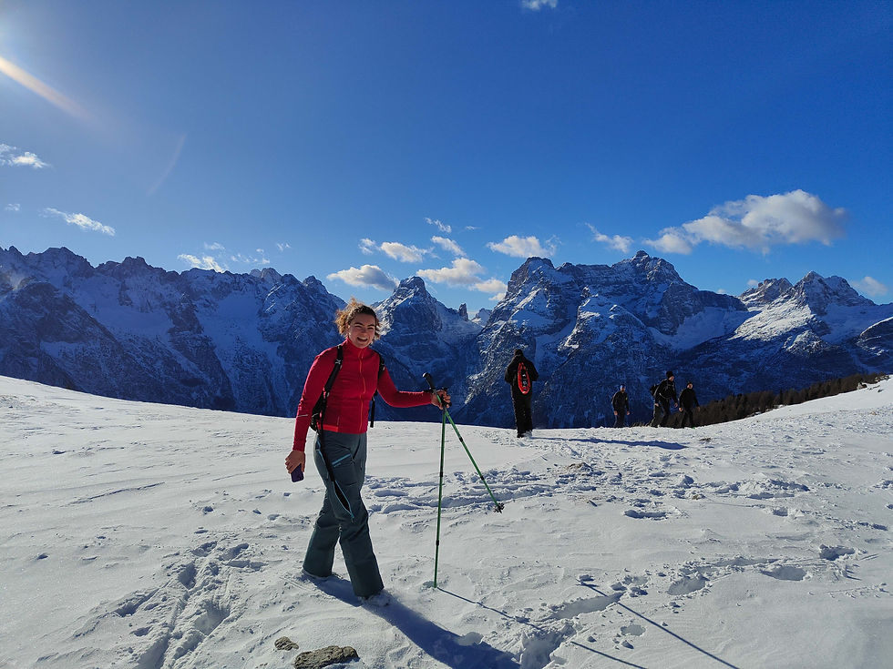
The Cadini di Misurina are famous, particularly abroad, for the stunning viewpoint accessible from the Auronzo mountain hut. I’ve heard many of my foreign clients assume that ‘Cadini di Misurina View Point’ was simply the name of the viewpoint, without realising that this spectacular cluster of spires and peaks is actually the Cadini mountain range. Here you can enjoy wonderful via ferrata hikes that take you almost close enough to touch these spectacular rock formations. In winter, it’s not possible to venture too far in (at least not with basic hiking gear), and the best way to admire the Cadini is precisely this easy hike. It’s a perfect snowshoe hike even for beginners, almost always well-trodden, and with a low avalanche risk (no need to say that with a risk level of 4 or 5 you stay at home, right?). The mountain hut is open on winter weekends and will welcome you with tasty traditional dishes.
The hike can be divided into two sections: the first part is quite steep and leads from Misurina to the Col de Varda mountain hut, at the top of the ski slope. The second part, which leads up to the mountain hut, consists of an initial downhill section followed by a gentle climb. Those wishing to make this hike easier can choose to take the chairlift up to Col de Varda and then walk only the second section.
Length: 11 km
Elevation gain: 500 m
Difficulty: moderate
Estimated time: 4 hours
Lowest point: Misurina, 1750 m
Highest point: Città di Carpi mountain hut, 2100 m
Refreshment points: Col de Varda mountain hut, Città di Carpi mountain hut


Itinerary
The route starts in Misurina, where the chairlift to Col de Varda begins and the ski run ends. Unfortunately, finding free parking is impossible: the chairlift car park is reserved for skiers, so you’ll have to leave your car on the opposite side of the lake in one of the pay-and-display car parks. Most bars and restaurants are closed in winter, unless it’s the Christmas holidays, so it’s difficult to find a café before setting off. In winter, the lake is often frozen over, and you can walk across it!
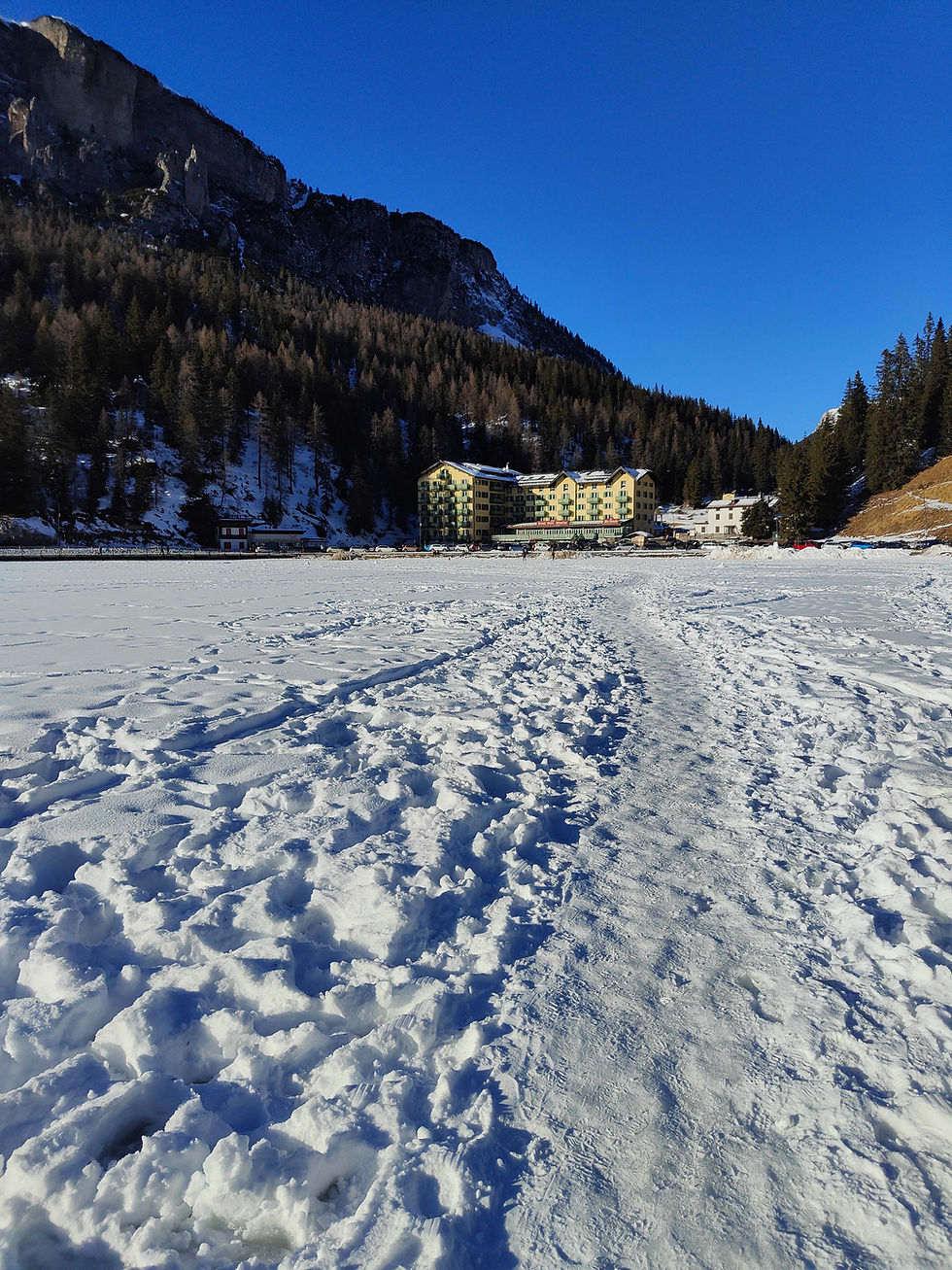
Pass the yellow building, which is not a hotel as many people think, but the Pio XII Institute, a sanatorium for children with asthma. Founded in 1896 as the Grand Hotel Misurina, it welcomed its first guest in 1900: none other than Queen Margherita of Savoy. In 1949, it was purchased by the Diocese of Parma, which converted it into a centre for the diagnosis and treatment of childhood respiratory diseases. Unfortunately, the institute closed permanently in 2022, due to the ever-decreasing number of patients (today, medical advances have made it possible to treat this condition with medication rather than through stays in the mountains).
From the chairlift car park, take path 120A; you’ll see signs already pointing towards today’s destination. After the first hairpin bend, you’ll come across a pretty little church with a stunning view of the frozen lake and Mount Cristallo. The summer road follows the ski run for long stretches, which isn’t possible in winter. You’ll therefore need to stay on the road for a few more bends, before leaving it and climbing up alongside the chairlift. The route is well-trodden and signposted, so you can’t go wrong. This section is quite steep, and perhaps not the most scenic as you’re walking beneath the operating chairlift; however, it’s also quite short: you’ll need to climb about 150 metres in altitude, then you’ll rejoin forest track number 120, and you can continue along that.
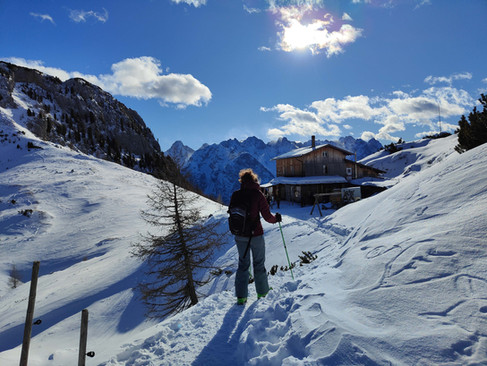
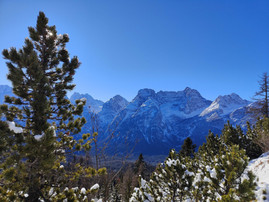
A little further uphill and you’ll reach the junction for the Col de Varda mountain hut. You can head up to the hut if you fancy a coffee (it’ll take about 10 minutes), otherwise carry on straight ahead. A short descent takes you out of the woods, where you’ll be greeted by a fantastic first surprise: a magnificent view opens up before you! The Sorapiss is unmistakable and imposing, whilst to its left you can see the Antelao (hard to recognise from this side!) and the entire Marmarole range.
After a mandatory photo stop, continue along the path, which now slopes gently downwards. Just before you re-enter the woods, you’ll notice a post marking the snow depth recorded in previous years – in 2020, there was a huge amount! The path continues to climb gently through the woods until you reach a fork: to the right, the path descends to Malga Maraia and San Marco in the valley floor, whilst you continue straight on. Don’t forget to turn around every now and then to admire the peaks of the Cadini behind you! A little more climbing and you’ll reach Forcella Maraia and the refuge. The view here is magnificent; as well as Sorapiss, the Marmarole and the Cadini, you can now also see Croda dei Toni.
The return journey follows the same route.


Can I do this at other times of the year?
Of course, the mountain hut is open in summer and the trail is absolutely stunning and very popular. In summer, there are plenty of wonderful hiking opportunities in the Cadini di Misurina, such as the Forcella della Neve loop, one of my favourites!
In autumn, this route is magnificent thanks to the larch trees turning shades of yellow and orange.
Variants
The mountain hut can also be reached from San Marco or Val Marzon; both routes are considerably longer than the one suggested here.
If there isn’t too much snow, you can take a different route back. Return to the junction for Malga Maraia and head down towards it. After about 10 minutes, in the hamlet of Cianpiete, you’ll find trail 120 B on your right, which, after a few ups and downs, will take you back to Misurina. Here you are no longer on a forest track, but on a narrow path through the woods, rarely used by other hikers. I recommend having a GPX track. The scenery is less varied, as you are constantly surrounded by woodland, but it’s nice to have the option of taking a different route for the descent.
Map and route

If you’d like a paper map, I’d recommend the Tabacco 17 map, ‘Dolomiti di Auronzo’, or number 10, ‘Dolomiti di Sesto’. However, I’d suggest using a good mobile app with GPX tracks.
With the guide
Why take this guided tour if you already have all the information? First of all, if you are not familiar with snowy environments, if you do not know how to assess avalanche risk, if you do not know the area and if you have never worn snowshoes, I do not recommend venturing out into the snow alone. The mountains in winter are dangerous and a mistake can be fatal. During the winter season, there are many mountain rescues, knowledge of the environment and respect for one's limits are increasingly neglected, so even thinking 'I'll follow the others' does not keep you safe. A guide, on the other hand, is an expert on the area and will guide you safely on this or other routes according to the conditions at the time and your level of preparation. If they consider this route dangerous, they will suggest an alternative one, so you don't waste your day!
In addition, the guide will accompany you beyond simply admiring the landscape: they will show you, teach you and explain what surrounds us. What mountain is that? What animals live in the forest? Why are the Dolomites special? The guide will answer your questions and help you discover the history and unique features of the place. This way, your day in the Dolomites will not just be a walk in the snow but a real experience that you will remember forever.
The guide will help you choose the right equipment and can hire you snowshoes and poles, as well as advise you on where to hire hiking boots and clothing. For certain locations, I offer a transport service from your hotel. This means you don't have to worry about driving, the route or equipment, and you can enjoy the day without any worries!
To book this or other excursions with me, visit the TAILOR-MADE EXCURSIONS page.
Disclaimer
This post was written based on my personal experience in the mountains.
You can use the information provided and the GPX track at your own risk; I accept no responsibility. Remember that the mountains are unforgiving.
Before setting off on your own, study the route carefully, check the weather and snow conditions, and make sure you have the appropriate equipment and clothing. If you are not an expert, do not go alone, but contact a guide.


Comments