
Tre Cime from Misurina
- Feb 2
- 6 min read

The Tre Cime di Lavaredo need no introduction; they are the most iconic and photographed place in the Dolomites. Every season, my clients from all over the world ask me to take them there. Personally, it is not a hike I enjoy. I certainly don't want to deny their majesty, nor the beauty of the peaks that can be admired along the classic Tre Cime loop; however, I don't like the confusion, the high concentration of unaware and rude tourists, or the eyesore of the huge car park at the Auronzo refuge. Added to this in winter is one of the things I hate most: snowmobiles, which race along the road all day long to bring customers up for a 'quick photo'. If this is your first time in the Dolomites, don't be fooled by those who promise (snowmobile service and even some guides) to take you to see the Tre Cime: they will only take you to the Auronzo refuge, from where you can see them, but only from the 'back', which leaves many disappointed. Now I'll explain why.
To see the famous north face, the one in all the photos, you have to reach Forcella Lavaredo from Misurina. We can divide the itinerary into two parts: up to the Auronzo refuge and from the refuge to the pass. The climb up to the refuge is not difficult (see description below), while the second part is at very high avalanche risk. The southern exposure and steep slope transform what is a trivial path in summer into a crossing that can be very dangerous. Unfortunately, sometimes it is not enough to check the avalanche report to know whether or not you can go (even they make mistakes): I have arrived at the refuge and decided that it was not safe to continue. Unfortunately, many of those who arrive here by snowmobile are unable to make these assessments and set off towards the pass anyway, perhaps with unsuitable footwear and without any equipment. So, if you decide to take this route, you must have a good ability to assess the snow conditions. Do not follow others in this game of Russian roulette!
Length: 15.4 km
Elevation gain: 800 m
Difficulty: medium
Estimated time: 5/6 hours
Minimum altitude: car park, 1900 m
Maximum altitude: Forcella Lavaredo, 2450 m
Support points: none


Itinerary
We set off on our excursion from Lake Antorno, about a 10-minute drive past Lake Misurina. There is a car park here, which is not very large but free, and a restaurant where you can have a last coffee before setting off. Snowmobiles also depart from here, so I recommend arriving early, given the length of the trip.
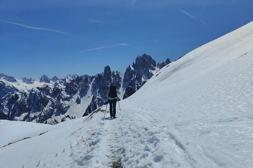
From the lake, we can already see the peaks in front of us: only two are visible, the third is hidden, and from the south side, which is the less famous one. Yet they are already beautiful from here! To reach the Auronzo refuge, you have two options: follow the summer road that snowmobiles also use, or take the trail. My advice is to go up the trail and down the road.

Follow the road to the toll booth (10 minutes), where you will find trail 119 climbing to the right. The trail is almost always marked, so it will be easy to follow. It immediately enters the woods, climbing steeply at times and gently at others. Every now and then, the trees open up to reveal the surrounding peaks. A final steep climb takes us back to the road, which we follow for the last few hairpin bends to the refuge (closed in winter). It is true, as I said before, that the Tre Cime are not beautiful from here (we are too close!), but the view is still magnificent! You can also see the two lakes, Misurina and Antorno, tiny at the foot of Sorapiss.
Now it's time to make the assessments I mentioned earlier. Is the avalanche risk low? Is the snow stable? Are there any signs of recent avalanches? Is the path well trodden? If so, you can continue along path 101, to the right of the refuge (the classic Tre Cime loop, anti-clockwise). The path is mostly flat, with magnificent views – a real spectacle! Pass the small Alpine church and you will reach the Lavaredo refuge (closed in winter). From here, a final climb leads to Forcella Lavaredo. After all that effort, you are finally rewarded with a view of the famous north face of the Tre Cime! This viewpoint, which is very crowded in summer, is now reserved for the few who manage to get this far, and you can really enjoy it all to yourselves.
For the return journey, retrace your steps back to the refuge, then you can choose whether to return along the same path you took on the way up or take the easier route (but watch out for snowmobiles and people coming down on sledges!).


Can I do it in other seasons?
In summer, the Three Peaks are very popular. Ninety-nine per cent of people drive up to the Auronzo refuge to walk the classic loop. The road is generally open from late May to mid/late October, depending on weather conditions. However, there are many other ways to see the Tre Cime, starting from Misurina. If you are fit, I recommend the complete Tre Cime loop from Lake Antorno: you climb the same route described here, continue on the loop, and then descend from Forcella de Medio. Another route I love is the Paterno loop to Pian di Cengia: magnificent and uncrowded.
As always, I advise against visiting during the thaw, for obvious reasons.
In autumn, it is certainly not the best place to admire the foliage.
Variants
In winter, there are not many other options besides the route proposed here. To see the Three Peaks in winter, there are only two options: this one, or climbing up to the Locatelli mountain hut via Val Fiscalina, starting from Sesto. Obviously, the logistics are very different, depending on where you are staying or where you are starting from.
The classic Tre Cime loop is NOT passable in winter with normal hiking equipment. The same applies to Forcella de Medio, which may seem attractive due to its proximity to the Auronzo refuge. You can reach the Forcella, but to see the Tre Cime you would have to continue along trail 105, which is impossible in the snow.
The famous Cadini di Misurina viewpoint is not accessible in winter. However, from the Auronzo mountain hut, you can take trail 117 in that direction and climb to the top of the hill visible from the hut. The view of the Cadini is still magnificent.
Map and route

If you want a paper map, I recommend Tabacco 010, Dolomiti di Sesto. However, I suggest a good mobile app with GPX tracking.
With the guide
Why take this guided tour if you already have all the information? First of all, if you are not familiar with snowy environments, if you do not know how to assess avalanche risk, if you do not know the area and if you have never worn snowshoes, I do not recommend venturing out into the snow alone. The mountains in winter are dangerous and a mistake can be fatal. During the winter season, there are many mountain rescues, knowledge of the environment and respect for one's limits are increasingly neglected, so even thinking 'I'll follow the others' does not keep you safe. A guide, on the other hand, is an expert on the area and will guide you safely on this or other routes according to the conditions at the time and your level of preparation. If they consider this route dangerous, they will suggest an alternative one, so you don't waste your day!
In addition, the guide will accompany you beyond simply admiring the landscape: they will show you, teach you and explain what surrounds us. What mountain is that? What animals live in the forest? Why are the Dolomites special? The guide will answer your questions and help you discover the history and unique features of the place. This way, your day in the Dolomites will not just be a walk in the snow but a real experience that you will remember forever.
The guide will help you choose the right equipment and can hire you snowshoes and poles, as well as advise you on where to hire hiking boots and clothing. For certain locations, I offer a transport service from your hotel. This means you don't have to worry about driving, the route or equipment, and you can enjoy the day without any worries!
To book this or other excursions with me, visit the TAILOR-MADE EXCURSIONS page.

Disclaimer
This post was written based on my personal experience in the mountains.
You can use the information provided and the GPX track at your own risk; I accept no responsibility. Remember that the mountains are unforgiving.
Before setting off on your own, study the route carefully, check the weather and snow conditions, and make sure you have the appropriate equipment and clothing. If you are not an expert, do not go alone, but contact a guide.


Comments