
Walker's Haute Route
- Jan 9
- 32 min read

Many have asked us why we chose this trek over the more classic and famous Tour du Mont Blanc. There were many reasons for our choice, but I'll give you the result: we haven't regretted it for a minute!
I discovered this trek by chance. Like many enthusiasts of long, high-altitude hikes, I was fascinated by the TMB, and I was looking for information on the stages. Then, by chance, I stumbled upon the Walker's Haute Route. A 14-day trek connecting Chamonix to Zermatt, crossing passes that reach nearly 3,000 meters, natural parks, and a stone's throw from imposing glaciers and crystal-clear lakes. I fell in love with it immediately! This trek is inspired by the classic Haute Route, a ski mountaineering route that connects the two mountain villages, crossing majestic glaciers. Following the success of this crossing, a hiking version was created, with no mountaineering difficulties, designed for those who enjoy simple walking. The more I learned, the more intrigued I became, and in my eyes, it even outperformed the TMB. I made a mental note and put the project aside for when the time was right.
We decided to take this trip one day in February, when in a hospital room our summer plans were shattered. So to cheer us up I said: "this summer we'll do the Walker's Haute Route!" and so it was.

Walker's Haute Route or Tour Du Mont Blanc?
But let's get back to the original question: why this one and not the famous Mont Blanc loop?
First of all, it started from a personal dream: I've always wanted to see the Matterhorn from the Swiss side, and the idea of reaching it on foot after 14 days of walking fascinated me.
Then the length: those who know me know I love a challenge, and if I could choose between an 8-10 day trek and a 14 day one, guess which one I'd choose...?
Finally, and this is also a personal choice, popularity. I know there are those who enjoy building a community along the way, meeting the same people every day, chatting, and getting together in the evening. These people will definitely prefer the TMB. I, on the other hand, like the quiet. We hiked the first two days on the TMB route, and in the middle of August, it was really crowded. It was a relief, I admit, when on the third day in Champex-Lax we said goodbye to the dozens of hikers heading towards the Grand Col Ferret and, accompanied by a handful of others, continued towards Mont Brulè. From there on, we encountered very few people, so it was easy to get to know each other after a few days of walking, and to exchange chats and information. But we also savored the solitude, slept with ibex, and walked for hours in perfect silence.
If all this piques your curiosity, come join us on this incredible journey!

Day 0: from home to Chamonix Mont Blanc
I'll start from here, even though the trip began much earlier, with months of planning, studying the stops, places to stop, supermarkets, and what to pack. But I can't tell you everything!
We left very early in the morning to face the long, hours-long drive to Brig, Switzerland. Here we were lucky enough to find free parking, and we continued by train. A word of warning: Swiss trains are EXTREMELY EXPENSIVE! To get from Brig to Chamonix, we paid 106 francs each, a real rip-off! The train ride was pleasant, though; we bought a kebab at a station and watched the valley rush by. In Martigny, the train began to climb the mountains, and continued into the valley just inches from the ravine!
We finally arrived at our destination, and we could look up at the majestic Mont Blanc! We avoided the crowds in the center and immediately headed to the campsite. They had us pitch our tents, squeezed in between the other hikers. It's crowded with people leaving, having finished, or doing the TMB. The campground is small and crowded, and the line for the few showers is incredibly long. The atmosphere isn't great; many are tired and nervous, and those arriving after us are forced to leave because the campground is full... We slip away as quickly as possible and take a stroll around town. It's really hot, much hotter than we thought! We buy some souvenir stickers and celebrate the start of this adventure with a delicious fondue!
Day1: from Chamonix to Col del le Balme
The night wasn't great, and the thin tent sheet doesn't protect you from the snoring of someone pitched a tent 30 centimeters away from yours... I get up well before the alarm goes off, and I take the opportunity to take one last shower—who knows when the next one will be! We pack everything up and head off to have breakfast at a pastry shop as delicious as it is expensive.
Now I need to make a little introduction. We spent weeks discussing and studying the route. We had 14 days to do a 14-day trek. A bit tight, considering we don't like rushing, and the weather is unpredictable. We also absolutely wanted to add two more stops: one at the beginning, to reach Lac Blanc, and one at the end, to sleep near Riffelsee. So we decided that to be able to reach these two lakes, we'd have to cut out something else. How? No buses, but the help of a few chairlifts. Some trekking purists might turn up their noses, but we don't care; we added two wonderful spots and skipped some boring ups and downs on ski slopes!
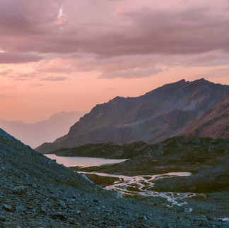
The official stage of the WHR runs from Chamonix to Argentiere, walking along the valley floor—not very interesting. So we took a chairlift to Brevent, and from there we hiked a magnificent high-altitude trail. The day was crystal clear and very warm, and the view of the Mont Blanc massif was unique. The long initial stretch, slightly downhill, with views of the Grand Jorasses was a real treat, the perfect start to our adventure! However, we enjoyed the climb up to the famous Lac Blanc much less. We weren't expecting so many people! The trail was so crowded that we compared it to one of the most famous Dolomite trails: it felt like going to Sorapiss! And arriving at the lake wasn't any better: loud music at the packed refuge, and people everywhere around these small lakes. Definitely not the ideal conditions for admiring them. A light wind was also stirring the water, preventing us from seeing the famous reflection. The best time to enjoy this spot is probably sunrise or sunset, but camping is prohibited here. So we continue on, and we quickly leave the crowd behind. Besides us, the only other people on the trail now are with large backpacks, speaking every imaginable language: they are hikers on the TMB. From here, the descent becomes incredibly steep, so steep that it's a continuous series of vertical ladders. After a while, I say to Luca, "I've never climbed so many metal ladders without a safety harness!" In fact, in our country, a trail like that would definitely be classified as a via ferrata, but here there's not even a sign! We're almost down the valley at around 4:00, baked by the relentless sun, and quite tired. Yet we see people now starting the climb! Who knows where they'll sleep, on such a steep trail and with the lake being prohibited?
We're finally down in the valley, and now we enjoy walking for a while in the shade of the forest. We pass a couple of villages and reach Le Tour. We have time to buy an ice cream at the bar, and we eat it on the chairlift, ascending to Col de le Balme. Below us, boring, sunny ski slopes: we don't regret our decision.
Once we reach the top, it's time to find a spot for the tent. There are already people near the chairlift: a couple is setting up their tent right below the arrival point, and two girls are doing acrobatics to wash themselves with the camel beg water. Luca finds a bit of shade and declares he won't move from there until sunset. I don't really like the spot; it's not flat enough, so I wander around a bit. Not far away, I find the perfect spot: wide, flat, with a breathtaking view, and far from trails and lifts. I drag Luca there, and we collapse in the microscopic shade to rest and eat chips. As we eat a hearty plate of spaetzle and watch a herd of chamois approaching curiously, as I massage my feet and watch the sun replace a huge full moon, I think to myself: I'm happy. I'm finally on this trek I've been dreaming about for years and planning for months. The first day was exceptional, and two weeks of adventure await us. As if that weren't enough, the forecast is perfect, and tonight's tent site is simply incredible. "This will be the most beautiful tent site of the trek," I tell Luca, but I still don't know the wonders that await us....
 |  | Length: 15.1 km Elevation gain: 750 m Elevation loss: 1350 m |
Day 2: from Col del le Balme to Arpette
We're at 2,200 meters, yet the night has been so warm and dry that we've slept without a tent cavity, and with our sleeping bags open. Every now and then, we open an eye at night, and through the tent's canvas, we see the moon shining like a beacon and the Mont Blanc glacier shimmering. Even when the alarm goes off at 6:00 a.m., we can see the mountains before we even get up. What more could we ask for? While we're having breakfast, the peaks are turning red and the moon is setting behind the mountains. We're increasingly grateful and excited.
We pass by the chairlift from the day before, where there are now more than 10 tents, one next to the other and on sloping terrain... Soon we're at the Col de Balme refuge (and here we enter Switzerland!), where we treat ourselves to a second coffee. We continue along a fantastic ridge trail, with various ups and downs. After a bend, the Trient Glacier suddenly appears before us—what a spectacle! As we continue toward the glacier, we can see the trail that awaits us today: a dizzying descent into the valley, and a very steep zigzagging climb on the other side. We can see the pass we need to reach, and honestly, it's a little scary—it seems vertical!
When we reach the valley floor, we stop at a bar for cake and a drink, and we take the opportunity to charge our phones. We have a small power bank with us, but we take advantage of every opportunity to get a little juice. My phone drains a lot because I'm doing the GPX route, taking photos, and checking the maps. I also activated an eSIM card so I can communicate and check the weather forecast.
We set off again around noon, with almost 1,100 meters of elevation gain above us and a sun beating down like a hammer. We're saved by the presence of many streams, which we use to cool off. Every drop of running water we use to wet our hats, our faces, and cool our wrists. It's still incredibly hot. We now find plenty of hikers taking the TMB in both directions, and those descending warn us about the incredibly steep climb (thank you so much!). Luca suffers from the heat much more than I do. I manage fairly well for the first two-thirds of the climb, but then I, too, can't wait to get there. We arrive at Fenetre d'Arpette at 3:00 AM and collapse in a patch of shade to drink and eat something. We're exhausted and sunburned, and at our feet lies my nightmare: an endless scree. On the way down, the roles are reversed: I suffer and Luca waits patiently. I don't like these rocks, you never know if they'll move or not, and I walk very carefully.
Finally, I breathe a sigh of relief, and we walk more quickly, first through meadows and then through the woods. It's after 6:00 AM and we need to find a tent site, but above all, good water. The trail offers us another gift: in the middle of the woods, a painted rock, about 3 meters by 3 meters, right next to a lively stream. We set up immediately, again with the tent uncovered today, so pegs aren't necessary. We don't have the view we had yesterday, but the stream is the best reward we could have asked for: we spend a good 20 minutes with our feet soaking in the cool air, we wash ourselves and our clothes. We have dinner of couscous and beans, and before 9:00 we're already in camp.
 |  | Length: 14 km Elevation gain: 1250 m Elevation loss: 1650 m |
Day 3: from Arpette to Arpelle
Already at 5:00 a.m., we see torches passing by our tent: they are the TMB hikers, wisely attacking the climb to Fenetre d'Arpette in the cool of the morning. Some look enviously at our elevated tent site. By 7:00 a.m., we're on our way too, and soon descend to Champex-Lac. We make a brief stop to connect to the internet, check the forecast, and withdraw some cash. As we set off, we unexpectedly bump into an old friend of Luca's, who is hiking the TMB with his partner! What a coincidence!
We leave the lake behind us, and with it the TMB: from here, those hiking this famous loop continue north toward Courmayeur, while we continue east toward distant Zermatt.
We descend further through pastures and villages, with beautiful stone and wood houses. During the descent, we discuss a problem we're facing: the heat. We had planned our stages to always sleep at altitude, both because we like sleeping high up and because in Switzerland camping above the tree line is permitted. However, this forces us to descend in the morning and begin the climb in the heat of the early afternoon. To make matters worse, since our route runs from west to east, it means we're always in the sun: in the morning we descend on the east-facing slope and in the afternoon we ascend on the west-facing slope. It's all wrong! On the other hand, since this trek is very high and close to the glaciers, we NEVER expected this heat, especially at night! So we make a first decision: we have to change the stages and reverse the route. There are no alternatives, because climbing in the afternoon under the sun is truly unnecessary suffering.

As we continue our descent towards Orsières, I have another idea that will change our journey. This will be the last town we'll pass through for the next five days, and the only large town before Zermatt. This means we'll have to do the shopping for five days! A lot of weight. So I suggest to Luca that we lighten our backpacks by sending a package. We'd spent months thinking about what to pack, like clothing and gear. But we expected very different weather: nighttime temperatures near freezing, and frequent thunderstorms. Instead, we realized we were wrong: even at high altitudes, it's hot at night, and the forecast doesn't predict a cloud for the next 10 days! Luca enthusiastically embraces my idea, so as soon as we arrive in town, we find a post office, buy a box, and put in our two down jackets, waterproof overpants, wool gloves, and a few other small items. We send a 6-kilo package, thus saving a good 3 kilos each!
It's then time to reload our backpacks with groceries. Choosing what to buy isn't easy; we want to keep weight low and calories high, avoiding things that require a lot of water or gas for cooking, or things that might not last in the heat. It takes us forever to choose five lunches, four dinners, and four breakfasts, but in the end we set off again, fully charged.
Again, we attack the climb at midday, under the scorching sun, with the aggravating circumstance of starting at a very low altitude, from 900 meters. We have to climb Mont Brulè, almost 2,600 meters, and we already know it will be impossible to get there today. We initially climb through pastures and villages, trying to take advantage of every shade provided by the trees. We voluntarily get washed by an irrigation pump, and in each village we dip our heads in the cool water of the fountain. We stop for lunch in the shade of a house, and a man gives us two peaches, a small gesture that brings us comfort. However, the climb is extremely steep and the heat is scorching; there's no escaping the burning rays, and we're soaked in sweat. Our backpacks, though lightened, feel like boulders, so loaded with food and water. We pass a few other hikers, struggling like us. We reach about 2,000 meters when we decide to stop. Luck has been on our side, and we've once again found a perfect spot: it's an alpine pasture, with lots of cows grazing, but they're fenced in higher up than us. A beautiful, flat meadow opens up to the side of the road we're climbing; it looks like it's been recently mown. A little further on, a cabin, and outside, a fountain! Behind us, the summit of Mont Brulè, and in front of us, splendid glaciers. We relax a bit, watching other hikers continue toward the summit. I would have loved to sleep up there, but I just wouldn't have been able to! While we're resting, a couple of Easterners arrive, also dripping with sweat and exhausted. We chat about today's route and plans for the next few days, then they ask if they can camp with us. Of course, we say yes, and they find a spot not too far away (but not close enough to hear them snoring!). Today we're using the water to wash ourselves a bit and wash our sweat-soaked clothes. A true luxury! But the greatest luxury we wanted to indulge in was at dinner: we bought a box of fondue, the ready-made kind that you just heat up. We couldn't wait, but... it turned out to be a real disaster! We only downed it because we were starving, but what a disappointment! On the other hand, the sunset didn't disappoint, and tonight we're putting up our tent with a view, without the tarp, so we can gaze at the stars.


Length: 16.6 km Elevation gain: 1100 m Elevation loss: 1050 m
Day 4: from Arpelle to Fionnay
The night wasn't entirely peaceful. At one point, a car pulled up, stopped, and stayed a while. We heard doors slamming and headlights flashing. We were a little worried, but we pretended nothing was happening, and after a while they left. They could have been shepherds checking on their animals, or a couple, or drug dealers. Luckily, they didn't bother us. We bid farewell to our new Eastern friends and begin the climb.
We finally fully enjoy the climb! The sun is starting to shine on the other side of the valley, while ours promises to remain in the shade for a few more hours. It's cool, we're rested, and our legs are finally moving as they should: at full speed without any effort. Every now and then, we stop to pick some blueberries; there are so many of them, big and truly inviting!

The last stretch on the ridge is a real blast, the view incredible. We reach the summit feeling like we've barely made a single effort! Looking back, I record a video that shows the entire route we've covered over the last two days—amazing! There are some war emplacements on the summit, and we spend some time exploring them before continuing on to the Cabane De Mille. Here we meet up with our friends, and discover they're from none other than Malaysia! They're also experts on these areas: the year before, they climbed the TMB and summited Mont Blanc!
At the refuge, we grab a slice of cake and a soft drink. I opt for a lemonade (they don't have the usual American brands of soft drinks here, no Coke or Pepsi, but they do have similar drinks, all made in Switzerland). But this time, it's a disaster; it's the most disgusting thing I've ever drunk!! It tastes—and I'm not exaggerating—like fizzy dish soap! Absolutely disgusting, for 5 francs! If it were up to me, I'd leave it there, but Luca heroically offers to finish it off, offering me his apple juice. I almost expect to see him blow soap bubbles!
We continue along a truly relaxing trail, past pastures, stone huts, blueberries, and cows. We're in truly great spirits today, enjoying every step. The decision to switch stages, climbing in the morning and descending in the afternoon, was a wise one, and as we continue, we chat about the new route. A miscalculation we made comes to our aid: around noon, we arrive at a beautiful blue lake, Goli di Servay, where we had planned to stop for the night! It couldn't have gone better: we can continue the descent to the valley floor, so we can start the climb the next day. But not before taking advantage of these crystal-clear waters for a nice swim! It was just what I needed to make this day perfect.
The afternoon continues with ups and downs to Cabane Brunet (ice cream stop), and then a very steep descent through the woods to the valley floor.
Finding a place to sleep here isn't easy. First of all, we have little water, so we absolutely must find a fountain. The streams here are very murky, due to the meltwater flowing down from the glaciers. Fionnay is a village of four houses and a hotel, built between two reservoirs that collect water from other dams upstream. We have no hope of finding a place to sleep, and we don't feel like starting the climb.
Luck favors us again, gifting us a small fountain. We immediately stop to fill our water bottles and wash up. We wander around a bit, finding ourselves in a small cluster of holiday cottages, surrounded by a small grove. We sneak into this space and find a small space suitable for our tent. We clear the ground of pine cones and twigs and have quickly created our home for the night! So few things do we really need... And speaking of needs, we're starting to realize we've bought far too little food! We're starving and we're eating our way through dinner that evening (rosti with speck) and lunch the next day (a delicious Rio Mare salad).
 |  | Length: 16.5 km Elevation gain: 900 m Elevation loss: 1150 m |
Day 5: from Fionnay to Col de Louvie
The night passes peacefully, once again very warm due to the low altitude. In the morning, we pass by the imposing power plant beneath the Fionnay dam. This electric hum is shocking to walk. In town, we stop at the bar to buy some sandwiches, to replenish the lunch we devoured the night before. Today, we face a significant elevation gain, over 1,600 meters! We begin the steep, switchback climb. It's a well-known spot, and there are many people climbing. Like the day before, we appreciate the cool morning air and the shade, and we climb quickly and effortlessly. The Cabane de Louvie is a spectacle, a chain of glaciers on one side and a blue lake on the other! The lake is man-made, part of the hydroelectric dam system we passed that morning.
Over a slice of the customary cake, we chat with an Italian man who the day before had done the same route we will be doing today and tomorrow. We exchange a bit of information, and he warns us about crossing a stream at the foot of a glacier.
We walk to the opposite side of the lake and find an old stable. The ceiling is made of vaulted stones; it's incredible they're still standing! Outside, a sign shows the valley before the dam: a veritable Garden of Eden, pastures and huts, and hundreds of cows. We continue the climb and are alone again. The lake behind us shrinks, while the glacier above it appears ever more imposing. We see the first edelweiss flowers, and a marmot, undaunted by us. The heat is now pounding, but we can see our destination not too far away. Before reaching the pass, we draw water from a tiny spring.
We finally reach the Col de Louvie, and the view that opens up is incredible: there's an immense glacier on one side, melting into a turquoise lake surrounded by dark scree. As if that weren't enough, a group of ibex is watching us from a few meters away!
Along with our Malaysian friends who have joined us, we head for the lake: we'll stop there to sleep, while they continue. This is the spot the boy at the refuge had warned us about. In fact, both the stream entering the lake and the one exiting are full of rushing, murky water. We watch from afar as our friends try to find a passage upstream, but they end up taking off their shoes and wading through the water up to their groins. We look for a passage for the next day, but even downstream, it seems the only option is to wade.
Anyway, for now, we relax. We pitch our tent on the lakeshore and eat a bag of chips from the bar. For the first time, we pitch a full tent, and while we're eating, large clouds gather. Tonight, we sleep at almost 3,000 meters! For dinner, we have freeze-dried pasta carbonara. Not bad, but we needed a bag each instead of one for two! While we're eating, a group of ibex passes us fearlessly, wading across the river and continuing toward the glacier. How exciting to see them like this! We have just enough time to admire a fantastic sunset, then it starts to thunder and we take refuge in the tent. It only rains a few drops, then everything calms down.


Length: 12.1 km Elevation gain: 1650 m Elevation loss: 300 m

Day 6: from Col de Louvie to Glacier de Cheilon
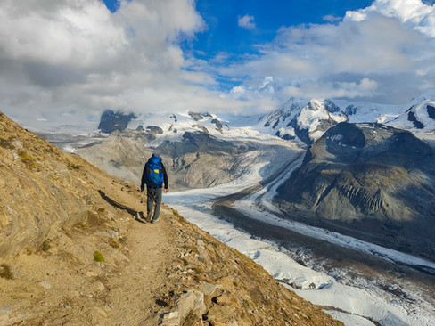
In the morning, a pleasant surprise awaits us: the water in the lake and stream has dropped! The cold of the night has slowed the glacier's melting, so the current is calmer. We can now cross without difficulty and continue toward the lakes above. This stretch is magnificent: we walk over black scree, and every now and then a small melted lake appears, reflecting the mountains. Downstream, we see a larger lake, and the stream that reaches it carves gentle serpentines through the green grass. On the final stretch to Col de Prafleuri, the scree becomes more difficult; we have to find the best path among large loose rocks. Luca is much more comfortable than I am in these situations, so I let him lead the way. We reach the pass at 2,987 meters, the highest point of the trek! To our right, a new, imposing glacier, while below us, we see a valley carved out and distorted by an old mine.

We descend into this valley and stop at the Cabane de Prafleuri to eat something and charge our phones. We also manage to connect to the internet, after days without it, and we can
check the forecast: thunderstorms in the afternoon.
We continue the climb toward the next pass. From below, it appears vertical, but in reality, there are comfortable switchbacks that quickly take us up. At the Col des Roux, a new spectacle opens up beneath us: a long, deep blue lake that ends at the Cheilon Glacier. It's Lac Dix, which we'd seen many times while planning the trip. It's truly stunning, and we're increasingly excited. On the descent, we spot a mother ibex with her calf. He looks at us curiously, while she continues to chew her cud peacefully. We pass two beautiful bivouacs (closed, but can be booked online) and reach the mule track that runs alongside the lake.
This stretch is beautiful, yet despite being flat, I'm starting to feel a bit tired; it seems endless! We stop for lunch (pre-cooked rice with tuna) and a bit of a rest. At the end of the lake, the mule track ends, and the steep climb begins again. Behind us, large black clouds gather, and we hear thunder. We're now on the moraine, at the foot of the glacier. The torrents flowing down are impressive, impetuous and powerful, carrying large rocks. Filling our water bottles is unthinkable. The plan was to climb up to the pass and find a tent along the descent on the other side of the valley, but at a certain point the wind picks up, and heavy raindrops begin to fall. A full-blown thunderstorm threatens. We make a quick decision: there's a tiny, flat space to the side of the trail, and in two seconds we've pitched the tent and taken shelter inside. As I lie down in the tent and rest my head on my backpack, I fall asleep, while the storm rages outside.
It doesn't last long, less than an hour, and we can go out to assess the situation. It's not yet 4:00, but we're tired, it might rain again, and the place isn't bad at all. So we decide to stop and rest. The only problem is that we have to ration water. As for food, we can use up our remaining supplies, because tomorrow we'll find a supermarket.


Length: 14.9 km Elevation gain: 950 m Elevation loss: 1000 m
Day 7: from Glacier de Cheilon to Molignon
In the evening, we decided on a new plan for today. After five days without passing through any towns and seven without a shower, we can't wait to reach the Arolla campsite! It's not far, we estimate about three hours, so the plan is to reach the village, do a big grocery shopping, go camping, and spend the afternoon showering, doing laundry, eating, and resting.
We set out with this goal in mind, and begin the final stretch of the climb. This is perhaps the most beautiful section we've done so far. We hike along a moraine, and below us we can see the glacier with its melting lakes. We take tons of photos; it's spectacular!
Unfortunately, the Pas des Chevres pass isn't accessible. We'd seen many photos of this pass, which is reached by a metal ladder. Unfortunately, we find signs warning that the ladder collapsed last year, and they redirect the trail to the nearby Col de Riedmatten. We traverse a few short, secured sections and reach the pass. We stop briefly and begin the long descent that awaits us to Arolla. We can see we're getting closer to civilization again; there are numerous ski slopes and chairlifts here.

As soon as we arrive in town, we go to the only small supermarket and buy just one day's worth of food (very expensive!), because we can restock tomorrow. Then we pop into the only open bar and celebrate the end of this long, isolated stretch with a delicious ice cream sundae!
We descend a little further to reach the campsite, but here we're in for a nasty surprise: the campsite is closed due to a landslide! Now that's a huge disappointment. As an alternative, the nearby hotel has set up a mini-campground: a parking lot, without a single tree, with portable toilets. What a disgrace! We immediately decide we won't stop. But what to do now? We're desperate for a shower and a rest. The official route includes a stage between Arolla and Les Hauderes, climbing up to the famous Lac Bleu and then descending back into the Arolla Valley itself. Very close to Les Hauderes, in Molignon, there's another campsite, but getting there in a day using this route is nearly impossible. We'd arrive late and tired, meaning no time for a shower and laundry. So we decide to alter our route, skipping Lac Bleu and simply descending to the valley floor to the campsite. I'm a little sad to skip the lake, but the valley floor trail also turns out to be very beautiful. We walk along the riverside, through meadows and stone villages. At lunchtime, we share a bench with two French ladies passionate about botany, with whom we have a lovely chat about local plants. When we cross the path leading down from the lake, we find a crowd of people and parked cars. Thinking back to our experience at Lac Blanc on the first day, we're no longer so sorry we skipped it!
We find ourselves in a quandary when, at a crossroads, we find our path blocked by a sign: TRAIL CLOSED. What to do? We're demoralized, hot, and tired. We decide to climb back up and continue on the paved road. But another problem arises: there's a one-way tunnel that appears to be long, narrow, and poorly lit. Too dangerous to navigate on foot. Our only option is to hitchhike. A girl saves us and offers to take us to the village. We're tempted, but we decline, and instead have her drop us off on the other side of the tunnel. We continue downhill through pastures and villages and finally reach the campsite. At reception, we almost have a heart attack when the owner tells us he doesn't have any space! Luckily, he takes pity on us and says he'll find us a small space if we settle for one. This is a luxury campsite; the Chamonix campsite would have crammed four tents into the "small space" they assign us. The bathrooms are also spotless and spacious, and we finally take a long, hot shower! We even have time to grab a beer at the bar while a storm rages outside, before a well-deserved dinner at the restaurant.
 |  | Length: 18.7 km Elevation gain: 450 m Elevation gain: 1700 m |
Day 8: from Molignon to Lac de Chateauprè
After shopping near the campsite, we begin the climb toward Col du Tsatè, 1,500 meters higher. The trail climbs steeply through woods and huts, then across pastures and finally onto scree. We reach the pass at nearly 2,900 meters, and after a short break, we begin the descent. So far, the trail has been beautiful, but nothing particularly exciting.

But as we descend, an incredible panorama opens up before us. We see four lakes, one above the other, each a different blue, and above them the majestic Moiry Glacier. We descend fascinated, each step closer to this wonder. I had seen this place in photos, and I couldn't wait to sleep on its shore, but the photos didn't do its majesty justice! We take dozens of photos of the first lake, Lac de la Bayenna. This isn't fed by the glacier, so the water is clear and clean, and the mountains reflect like a mirror. We descend toward the central lake and spend some time wandering around and taking photos. A road leads to the lake and there's a parking lot, so it's also quite crowded. We perch on a giant bench, overlooking the lake and glacier, and eat chips while waiting for everyone to leave. When almost everyone is gone, we pitch our tent on a magnificent flat spot right in front of the lake. How wonderful! This tent site beats them all! (For now!?). There are other tents around the lake, but ours is definitely the most beautiful spot. We eat the best rosti with pancetta with a view, and retreat to the tent as it starts to thunder.


Length: 12.5 km Elevation gain: 1550 m Elevation loss: 600 m
Day 9: from Lac to Chateauprè a Trient
After a breakfast of coffee, croissants, and a sunrise over the glacier, we begin the climb toward the Cabane du Moiry. This is the only detour on the trek, so we'll have to backtrack almost to the lake. But it's worth it: along the trail, we can admire the lakes and the valley from a different perspective, and once we reach the refuge, the view is incredible! We're now right above the glacier; it feels like we can touch it! The excitement is overwhelming; we're in seventh heaven! Plus, we eat one of the best brownies I've ever tasted!

As we descend, we encounter more and more people; it's a very popular route. But then we leave the main trail and only see a shepherdess tending her black cows. This stretch is simply magnificent: a long, seemingly flat stretch above Lac de Moiry, so blue it makes the sky envious. Finally, a steep climb takes us to the Corne de Sorbois, with a new view of new glaciers.
From here, the descent would be a long forest road on ski slopes. We're tired and want to rest a bit, so we take the chairlift, which quickly takes us to the valley floor. Along the descent, we see a peak appear on the horizon: it's the Matterhorn, our destination!
In Zinal, we stop at a pastry shop, which claims to be "the best in Switzerland," because we want to try Swiss hot chocolate. What a disappointment!! They bring us a huge mug of long-life milk, with a piece of chocolate to melt inside, for 6 francs! We'll do some grocery shopping for the next two days and head to the campsite for a long, hot shower. For dinner, stewed sausages and beans—a protein boost!


Length: 17 km Elevation gain: 1150 m Elevation loss: 800 m
Day10: from Trient to Gruben
A steep climb quickly lifts us above the valley, before continuing on a slight slope through pastures and mountain huts. The WHR has a few variations, but they all meet in Zinal, so today we find more hikers taking this trek, and those who have chosen the more northern routes. There's a French couple and a group of about ten Americans, plus many others. Evidently, the northernmost routes are more popular, yet we've passed closer to the glaciers. We chat a bit with someone, a great excuse to take a break during the climb! We climb over the Forcletta, but despite scanning the horizon, we can't see the Matterhorn. A steep descent punctuated by stops for blueberries and raspberries brings us near the village of Gruben. We wander around the village, but there doesn't seem to be a suitable place to camp. Almost everyone heads for the only hotel. Eventually, we find a small, fenced-in picnic area, and we decide that it will be fine for tonight. We have a plentiful supply of food, and spend the evening relaxing, eating, and bathing in the river.
 |  | Length: 17.6 km Elevation gain: 1300 m Elevation loss: 1150 m |
Day 11: from Gruben to Sankt Niklaus
The climb today is incredibly steep, with no break from the village to the Augstbord Pass. We meet up with all the friends from the previous day, and at the top of the pass the group of Americans applauds us for completing the climb! Some threatening clouds are gathering on the horizon, so we descend quickly. We have to cross a nasty scree slope, the kind I hate, and that slows me down a bit. I'm starting to get really tired, and I can't wait to get there. A beautiful traverse takes us around the mountain, and we emerge right above the Zermatt valley. From here, we can see the entire valley, surrounded by its glaciers, but... still no Matterhorn! We continue on a seemingly endless descent, all the way to Jungen. Here, there's a chairlift, which will skip the last leg-breaking stretch of the descent and take us directly to Sankt Niklaus. This is an old cable car, which operates on demand: when it's full (4 people), you have to ring the bell and ask to be let off! We're in the cabin with a French couple, and it takes us a while to figure out how it works.
In town, we enjoy a well-deserved ice cream before catching the bus to Grachen.
We spent a lot of time, both before the trek and during the hike, discussing how to combine the last stages. Officially, from St. Niklaus, the trail climbs to Grachen, then continues along the Europaweg to Zermatt, for a total of two more stages. The Europaweg is a wonderful trail, with a long, seemingly flat traverse overlooking the entire Zermatt valley. However, there are some issues that have given us pause.
First of all, a section of this trail is closed due to a landslide. This forces all this year's hikers to descend into the valley and then back up, which adds 1,000 meters of elevation gain both uphill and downhill—essentially an extra day.
Camping is not easy; the terrain is steep and prone to landslides.
We want to add the Stelleisee and Riffelsee lakes, which adds another day.
Finally, the weather decided to change. We went faster than expected, and we still have four days left, but the next two are forecast to rain.
To add to all this, we're a bit tired, so we finally made this decision: we'll spend the two rainy days in a room in Gruben (the only place we found that would cost 100 euros a night), then we'll take the train for a bit, and then we'll get back on the trail right after the section closed due to a landslide.
So we'll spend two days relaxing, one day as tourists in Zermatt, and one day watching the rain.

Length: 13.2 km
Elevation gain: 1100 m
Elevation loss: 950 m
Day 12: from Sankt Niklaus to Riffelsee
Recharged, we return to Sankt Niklaus and take the train to Tasch and the bus to Taschalp. Here, we resume the trail immediately after the section closed due to a landslide. Unfortunately, we're immersed in thick fog. We're very disappointed, because this section should have been really beautiful, with the Matterhorn right in front of us... Plus, I couldn't wait to see the mountain reflected in the lakes... I'm very depressed, but there's nothing I can do, so we continue through the fog for several hours.

Every now and then along the side of the trail, there are small bunkers built into the rock, to be used in case of landslides. What an impression! When we reach the end of the Europaweg, the fog begins to lift, revealing the valley floor. As we continue toward the first lake, the Matterhorn slowly comes into view, first just the peak, then the entire thing. How wonderful! Now the trail is very crowded, with hundreds of people disembarking from the train and chairlift, making the short hike to Stelleisee. But we made it here on our own two feet from Chamonix!! The Matterhorn revealed itself just for us, to reward us for our effort! We finally reach the lake, and the situation is very similar to what we saw a few days ago at Lac Blanc: lots of people crowded together, and no reflections due to the wind. Never mind, I'm already happy the fog is gone! We eat a sandwich and continue on the five-lake tour. Once we reach Grunsee, we begin climbing towards Riffelsee. Now there's no one left, and the sun is shining again. The landscape is magnificent, but the place is devastated: ski slopes, pylons, chairlifts, mountain huts, construction sites, artificial lakes, and garbage everywhere! But be warned: camping is prohibited, because you'll crush the grass! How disgusting!
A few meters before the lake, there's a cogwheel train station, and dozens of people disembark to photograph this famous spot. We're here for the lake, too, but... I wasn't expecting this view! A huge glacier opens up before us, and peaks with familiar names: we're on the Swiss side of Monte Rosa! We reach the lake, and it's magnificent. You can see a bit of reflection, but unfortunately the summit of the Matterhorn is hidden by clouds. We sit for an hour to see if it clears, but nothing. Never mind, we're planning on returning for sunrise.
We set off again, this time heading toward Monte Rosa. This stretch of trail is surreal: a long, flat, comfortable path, with Monte Rosa in front, the Matterhorn behind, and a glacial tongue below us. We see marmots and ibex. I have no words to describe the excitement this last stretch gave us. It was definitely the highlight of our trek! But today the excitement doesn't end, because at the end of the trail awaits the coolest tent site of the trek! We've been to many amazing tent sites, but this one beats them all! We take dozens of photos of our tent facing the glacier in the sunset light, and celebrate our last dinner on the WHR with hot dogs with cheese and bacon.
As soon as it starts to get dark, we go to sleep, as tomorrow we have an early alarm....


Length: 23.4 km Elevation gain: 1400 m Elevation loss: 900 m
Day 13: from Riffelsee to Zermatt
The alarm rings at 5:00 a.m., but for a good cause. We leave the tent and are greeted by the spectacle of the stars. They cast so much light that they seem to reflect off the glacier. On both the Rosa and the Matterhorn, we can see the lights of the climbers ascending toward the peaks. However, the ice floe beneath us is hidden by a cloud, which seems to act as a blanket for the night. We quickly dismantle our tent for the last time and retrace the previous evening's path. As we continue, the dawn light chases away the darkness, and the mountains come into sharper focus. It's an indescribable spectacle, and we feel privileged. We continue in silence, enjoying every subtle variation of light and shadow before us.


We arrive at Riffelsee, and it's simply perfect: the Matterhorn is clear, and the water is a mirror. It's so beautiful!
We're not alone; there are a few people who arrived by train, others are packing up their tents. It's very cold. We admire the spectacle in silence, waiting for dawn.
Unfortunately, the cloud that previously covered the glacier has lifted, has climbed over the pass, and we see it descending inexorably toward us, until it completely envelops us in a thick fog, making the air even colder. We can no longer see a meter ahead. We're disappointed, but we're not complaining; it's already been a magical gift. We take out the stove and start heating coffee as dawn comes and goes. Then the miracle happens, the last magnificent gift these lands bestow on our journey: the fog lifts, revealing the sharp outline of the Matterhorn, ablaze by the dawn sun, reflected in the mirror-like lake! It's impossible to describe the emotion of the next few minutes, which we spend in admiring contemplation.
The time comes to set off again; now only a long descent to our final destination awaits us. The valley is shrouded in cloud. We first descend along a beautiful path where we encounter only a small group of chamois, then we slalom between mega-luxury hotels, chairlifts, and train tracks. The final surprise is a long bridge that takes us across a small valley, lined with train tracks.
We arrive in Zermatt around 11:00, so I can stop the GPS track and declare our great feat complete! The town is packed with tourists; with our large backpacks, we struggle to make our way through the crowd. We reach a bakery, where we enter to celebrate.
Finally, it's time to catch the train, which will take us back to Brig, where we have a car and a hotel booked for a long shower before heading back.


Length: 12.9 km Elevation gain: 100 m Elevation loss: 1150 m
Considerations and suggestions
If you've read this far, you've already understood what I think of this trek: I loved it, everything was perfect, I could do it again tomorrow! I don't regret choosing it over the TMB in the slightest, and I highly recommend the two side trips we took, to Lac Blanc and Riffelsee.
Camping here is a joy: wonderful places await, and there are countless options. You don't need to spend hours on the computer (like I did) marking all the possible tent sites on the map after seeing videos and Google Maps.
Regarding technical difficulties, we encountered almost none. Aside from the downhill section from Lac Blanc (which isn't part of the official route), we only encountered a couple of spots with safety ropes, but nothing too difficult. The biggest challenges are the length of the stages and the demanding nature of the long elevation gains, and for those who choose to camp, the five-day hike will be without supplies.
Of course, it's also possible to do this trek while sleeping in a refuge; you'll find dozens of websites online that offer this option.
Regarding the alternatives, there are two, which can significantly change the overall experience of the trip. We always chose the southernmost ones, because they're higher up and closer to the glaciers. In the first case, we chose the longer one; in the second, the shorter one. Obviously, I can't say what the other options were like, but looking at the maps and some videos, they seemed more appealing to us, and we didn't regret it.
Switzerland is expensive, as we all know. Our expenses were: trains from Brig to Chamonix and from Zermatt to Brig, four chairlifts, three nights camping, supermarket groceries, cakes and drinks in the mountain huts, and two dinners in restaurants. In any case, at the end of the holiday, we spent a lot, even excluding the two nights in a room in Gruben. Consider that on average, two slices of cake and two cans of soda in a mountain hut will set you back 30 francs. Food in the supermarkets is also expensive, and if you're not careful, you can end up spending 100 francs for two days' worth of provisions. Campsites, on the other hand, have better prices, 30-35 francs for a tent and two people. In our experience, eating in restaurants isn't worth it: exorbitant prices and mediocre food.
Regarding cell phones, we tried to use them as little as possible. We got an eSIM card so we could check the weather forecast every now and then, but the network was poor along the route. As for charging, we made do with a power bank for two, and every break at the refuge was a good time to plug in, even if it was just for 10 minutes.
We set out equipped for freezing temperatures, but instead we found ourselves dealing with the heat. Of course, it won't always be like this, but if you're planning this trip, don't make our mistake and check the temperatures carefully. Even at night, it was always warm and dry, even at 2,900 meters. For us, who are used to it here in the Dolomites, where as soon as the sun goes down everything gets soaked with humidity, it was an indescribable joy to spend several nights without the tent cover and wake up perfectly dry!
On my Instagram page, you can find a photo/video account of the trip in the highlights.
I hope I've convinced you to embark on this adventure!
Have a good hike!


Comments